 |
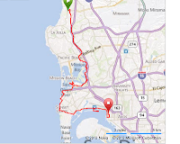
| Bike path route from UCSD to SD |
I plotted out a gpx file and put it in my Garmin 500. Maybe I could sort-of follow it on the "bread crumbs" tracker trail. I started the Bike Path route at UCSD and went tracking from there. It sort of worked... it shows a arrow and the arrow changes direction as you ride along the route OR get off the route. Better than nothing, but not much.
From Rose Canyon Bike Path and Santa Fe St., I went straight over to the Rose Creek Bike Path. Then jogged over to the Mission Bay Bike Path as it winds around Anza Cove, Fiesta Island and connects with the Sea World Bike Path. Then it's off looping around confused on Dana Landing and Quivera roads before crossing over the bridge and onto the Ocean Beach Bike Path.
 |
| Mission Bay Bike Path speed limit! |
Looks like this route will work for a DART route. Nice way to get downtown instead of the shorter Mission Bay Dr./Pacific St traffic lanes!
keep lookin'
-randorides
 |
| MB Bike Path by Anza Cove |

No comments:
Post a Comment